
In construction, success is defined by delivering high-quality, cost-effective, and sustainable infrastructure—on time, within budget and with safety as a high priority. That challenge is becoming harder to meet, as projects grow in complexity, resources remain tight, and risks—from supply chain disruptions to weather extremes—demand better decision making and faster coordination.
Location intelligence is transforming work in this environment, helping contractors, project owners, and field teams work more efficiently, collaboratively, and safely. At the center of this transformation, geographic information system (GIS) technology is redefining how construction projects are planned, managed, and delivered.
One of the most stubborn challenges in construction is coordinating the many moving parts of a project: field crews, office staff, subcontractors, vendors, and inspectors—all operating on tight timelines and budgets. Esri’s construction-focused GIS solutions help by providing a single, location-driven view of the project.
Whether it’s viewing underground utilities before digging, mapping logistics for material deliveries, or monitoring the movement of equipment and people in real time, location intelligence connects the dots across the project. With everyone working from a map-based platform, teams can reduce miscommunication, eliminate data silos, and keep projects on track.
Location intelligence is like a digital glue – it connects data, teams, and decisions—creating a shared system for better communication and faster problem-solving.
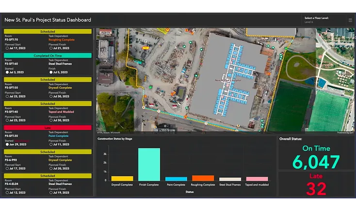
Real-Time Optimization in the Field
The benefits go well beyond better planning. By integrating GIS into field operations, teams can track labor, materials, equipment, and progress with exceptional clarity. This real-time awareness helps project managers adapt quickly to evolving site conditions, streamline logistics, and reduce costly downtime.
Imagine being able to view the exact location of incoming deliveries, monitor weather impacts on different parts of the jobsite, or assess safety risks based on real-time activity. With Esri’s GIS technology, these capabilities are becoming best practice for successful project execution.
The result? Safer sites, optimized resources, and fewer surprises.
Too often, valuable data generated during construction gets lost during project closeout. Esri solves this with its location intelligent digital delivery capabilities that span the full project lifecycle. This geospatially enhanced dataset becomes the foundation for operations and maintenance, giving owners a complete view of their new asset from day one.
Unlike traditional closeout packages, which may consist of disjointed PDFs or static models, the GIS-enabled digital handover ensures a strong link between construction and operations. This not only improves long-term asset performance, but also strengthens relationships between contractors and clients, allowing builders to become ongoing partners rather than one-off vendors.
A Smarter Way to Build
At its core, location intelligence helps construction professionals become more flexible, resilient, and future-ready. By enabling real-time monitoring, optimizing workflows, and creating a complete record of the built environment, GIS transforms how teams navigate the complex and often chaotic nature of construction.
It also helps meet the rising demands for sustainability and accountability. With greater insight into resource usage, environmental constraints, and community impacts, project teams can make smarter decisions that align with both budget and social responsibility goals.
As the construction sector continues to embrace digital transformation, location intelligence stands out as one of the most impactful innovations. From initial planning to final handover and beyond, Esri’s GIS solutions are driving a smarter, safer, and more connected way to build.
For more on how Esri is transforming construction with location intelligence, visit https://go.esri.com/dive_april.
View the original article and our Inspiration here
Leave a Reply